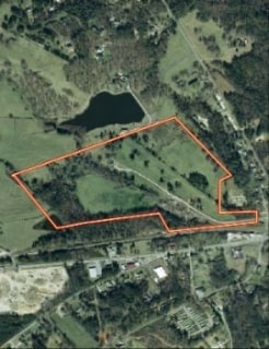
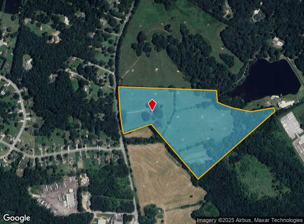
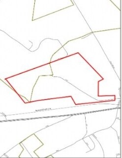
Property Record
189 Etheridge Rd, Auburn, GA 30011
NEARBY LISTINGS FOR SALE OR LEASE
Property Detail
189 Etheridge Rd
Atlanta-Sandy Springs-Roswell, GA
Barrow
XX010-019
Georgia
Ruralagriculturalresidence
28.90 AC
X
Barrow County
13013C0040D
Atlanta
1,755 SF
DEMOGRAPHICS near 189 Etheridge Rd
1 Mile
3 Mile
5 Mile
2024 Total Population
3,581
20,709
70,830
2029 Population
4,097
23,610
77,790
Pop Growth 2024-2029
+ 14.41%
+ 14.01%
+ 9.83%
Average Age
37
37
38
2024 Total Households
1,181
6,786
22,354
HH Growth 2024-2029
+ 14.99%
+ 14.53%
+ 10.28%
Median Household Inc
$68,464
$77,890
$94,886
Avg Household Size
3.00
3.00
3.10
2024 Avg HH Vehicles
2.00
2.00
2.00
Median Home Value
$233,871
$242,554
$296,187
Median Year Built
1996
1997
2001
Nearby Places
Map Layers
Map Styles
 Street
 Aerial
- Restaurants
- Banks
- Shops
- Fitness
- Groceries
Nearby Properties
Address
Land Use
TOTAL SIZE
Lot Size
Zoning
Address
Land Use
TOTAL SIZE
Lot Size
Zoning
891.66 AC
R100
Address
Land Use
TOTAL SIZE
Lot Size
Zoning
134,673 SF
29.74 AC
RA200
Address
Land Use
TOTAL SIZE
Lot Size
Zoning
222,481 SF
23.20 AC
M-1
Address
Land Use
TOTAL SIZE
Lot Size
Zoning
Address
Land Use
TOTAL SIZE
Lot Size
Zoning
202,250 SF
36.80 AC
M-1
Address
Land Use
TOTAL SIZE
Lot Size
Zoning
137,200 SF
20 AC
M-2
Address
Land Use
TOTAL SIZE
Lot Size
Zoning
84,363 SF
20.80 AC
C-2
Address
Land Use
TOTAL SIZE
Lot Size
Zoning
26,616 SF
0.70 AC
Address
Land Use
TOTAL SIZE
Lot Size
Zoning
26,616 SF
0.70 AC
Address
Land Use
TOTAL SIZE
Lot Size
Zoning
75,160 SF
14.82 AC
C2
Address
Land Use
TOTAL SIZE
Lot Size
Zoning
363.92 AC
RA200
Address
Land Use
TOTAL SIZE
Lot Size
Zoning
151.81 AC
Address
Land Use
TOTAL SIZE
Lot Size
Zoning
129.04 AC
Address
Land Use
TOTAL SIZE
Lot Size
Zoning
15,169 SF
5.71 AC
M1
Address
Land Use
TOTAL SIZE
Lot Size
Zoning
65,500 SF
10.50 AC
DOWNTOWN O
Address
Land Use
TOTAL SIZE
Lot Size
Zoning
24,400 SF
20 AC
M-2
Address
Land Use
TOTAL SIZE
Lot Size
Zoning
60,307 SF
33.40 AC
AG
Address
Land Use
TOTAL SIZE
Lot Size
Zoning
105.46 AC
Address
Land Use
TOTAL SIZE
Lot Size
Zoning
387.40 AC
AG
Address
Land Use
TOTAL SIZE
Lot Size
Zoning
1,736 SF
24.20 AC
RM8
Address
Land Use
TOTAL SIZE
Lot Size
Zoning
2,455 SF
14.70 AC
RM8
Address
Land Use
TOTAL SIZE
Lot Size
Zoning
7,800 SF
2.20 AC
PSV
Address
Land Use
TOTAL SIZE
Lot Size
Zoning
6,000 SF
25.40 AC
M-2
Address
Land Use
TOTAL SIZE
Lot Size
Zoning
8,696 SF
1.31 AC
C2
Address
Land Use
TOTAL SIZE
Lot Size
Zoning
36,450 SF
7.80 AC
M-2
Address
Land Use
TOTAL SIZE
Lot Size
Zoning
9,945 SF
5.24 AC
RA200
Address
Land Use
TOTAL SIZE
Lot Size
Zoning
137.73 AC
RA200
Address
Land Use
TOTAL SIZE
Lot Size
Zoning
2,300 SF
1.01 AC
C2
Address
Land Use
TOTAL SIZE
Lot Size
Zoning
3,960 SF
5 AC
M-2
Address
Land Use
TOTAL SIZE
Lot Size
Zoning
100 AC
RA200
The World's #1 Commercial Real Estate Marketplace
Connect with us
© 2025 CoStar Group
The information above has been obtained from sources believed reliable. While we do not doubt its accuracy we have not verified it and make no guarantee, warranty or representation about it. It is your responsibility to independently confirm its accuracy and completeness. Any projections, opinions, assumptions, or estimates used are for example only and do not represent the current or future performance of the property. The value of this transaction to you depends on tax and other factors which should be evaluated by your tax, financial, and legal advisors. You and your advisors should conduct a careful, independent investigation of the property to determine to your satisfaction the suitability of the property for your needs.